
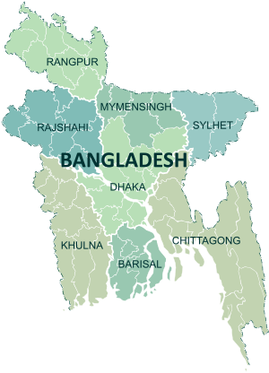
Bangladesh is divided into eight administrative divisions, each named after their respective divisional headquarters: Barisal,Chittagong, Dhaka, Khulna, Mymensingh, Rajshahi, Sylhet and Rangpur.
Divisions are subdivided into districts (zila). There are 64 districts in Bangladesh, each further subdivided into upazila (subdistricts) orthana. The area within each police station, except for those in metropolitan areas, is divided into several unions, with each union consisting of multiple villages. In the metropolitan areas, police stations are divided into wards, which are further divided into mahallas.
There are no elected officials at the divisional or district levels, and the administration is composed only of government officials. Direct elections are held for each union (or ward), electing a chairperson and a number of members. In 1997, a parliamentary act was passed to reserve three seats (out of 12) in every union for female candidates.[208]
| Administrative Divisions of Bangladesh | |||||||
|---|---|---|---|---|---|---|---|
| Division | Capital | Established | Area (km2)[209] | Population[209] | Density[209] | ||
| Barisal | Barisal | ||||||
| Chittagong | Chittagong | ||||||
| Dhaka | Dhaka | ||||||
| Khulna | Khulna | ||||||
| Mymensingh | Mymensingh | ||||||
| Rajshahi | Rajshahi | ||||||
| Rangpur | Rangpur | ||||||
| Sylhet | Sylhet | 1 August 1995 | |||||
No comments:
Post a Comment